This column originally appeared in the February 2026 issue of Town&Gown magazine.
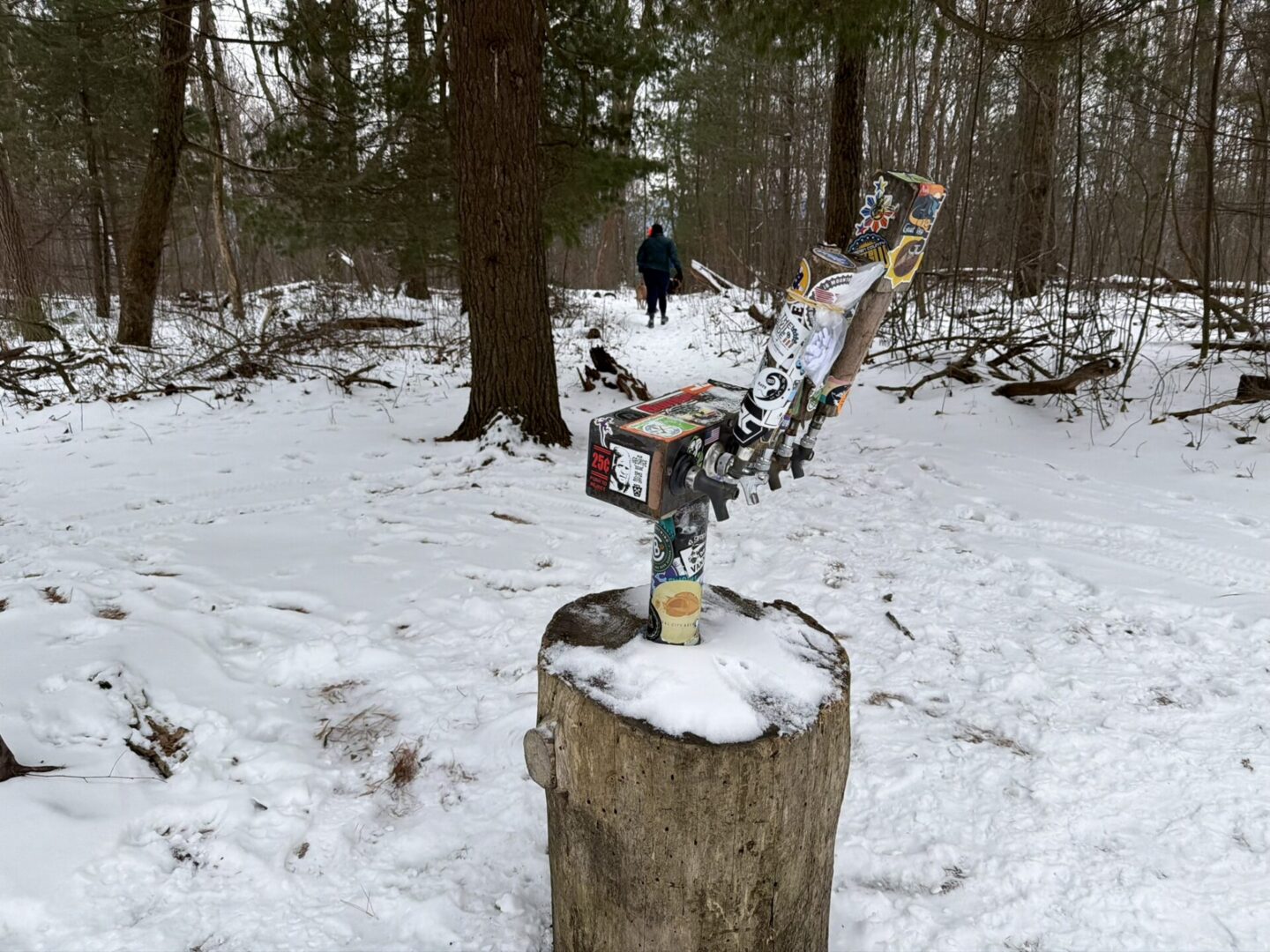
If you need proof that trail folk around these parts like to laugh and have a good time, I have just the thing for you. Up on the Tussey Mountain Ridge (yes, the same ridge as the ski slope), at a junction between trails, you will find that proof perched on a large stump; what is known as the Beer Tap.
The Beer Tap is exactly what it sounds like, an actual beer tap that is wedged into a log. Now, don’t get too excited, the lines are dry (trust me, I have tried many times), but it is still a fun thing to find on a hike, bike, or run. Located at the cross section of the Tussey Mountain Trail and what is Dylan’s Path on the western side, and the Tussey Mountain Extension Trail to the east, there are many different routes to this interesting landmark.
Purple Lizard Maps makes an excellent map of Rothrock State Forest that is a must-have when exploring the area. On it, you will find the Beer Tap and see that there are many ways to get there. Just know that they all take a little bit of effort.
The Tussey Mountain Trail is a personal favorite. Stretching about four miles along the ridge from the trailhead on Bear Meadows Road to the Beer Tap, this trail takes you on mostly gentle up and down sections that are fun for those on two feet or two wheels. Hiking this trail does go on a long time, but there are many places that offer wonderful views as you travel along the ridge. The Beer Tap is a fun place to stop for a snack and maybe even a “summit” beer (but you have to bring your own, and water may be a better choice).
There are many other ways to get up the Tussey Mountain Trail, such as one I have been taking recently by starting at Colyer Lake on the other side of the ridge. It was on a cold day in January when my pup Peggy last took that route with some friends over winter break.
We started at the Colyer Lake south parking lot and headed clockwise on Hobie’s Trail, which makes its way around the lake. After a quarter of a mile or so, we crossed the road and made our way to the beautiful Rattlesnake Canyon Trail.
After a brief walk through a field, we hiked along a lovely, mostly frozen stream, and because it was cold, there was no need to worry about the trail’s namesake (although I do not know if there are indeed slithery friends down in this canyon. It just may be named after a snake because the trail weaves in and out and includes an intensely steep up and down section that we avoided by taking the alternative route towards the back half of the canyon).
I was a little chilly when we started our trek, but we warmed up quickly as we made our way out of the canyon and up the next section. Now, some part of this trail is on private property, which is closed during rifle hunting season. It is important to be respectful and, as always, leave no trace. Show some gratitude to the landowners who allow a little bit of adventure on their property by following the rules that are posted.
We worked our way up the incline on some switchback that made for a gentle, but challenging grade, especially with the snow. Peggy and her buddies had no trouble, but for those of us with two legs, the snow slowed us down.
After about 2.5 miles of hiking, we finally made our way to the top of the ridge and to the Beer Tap. In all, it is a big climb of over 1,000 feet to make it up to the top of the ridge, and I was feeling it (as you could tell by the sweat soaking through my sweatshirt).
But we were rewarded by the nice folks from Purple Lizard Maps, who left some cool stickers there on the taps, free for the taking. That was a nice surprise, and I grabbed one for my water bottle.
The taps themselves are covered in stickers from local breweries, outdoor businesses, and others left behind by hikers and bikers. Again, I tried to pull one of the taps (I have to do it), but nothing came through (denied). Still, it was a fun place to catch our breath and try to get a photo of the pups (they were having too much fun to fully cooperate, but we got some good ones).
Now, I do not know who put this wonderful little landmark up on this ridge, but I love it. On this cold morning, we left our “summit” beers at home, and I was kind of sad about it. But I was still happy to reach our destination and share a laugh with some friends.
It was cold that day, so we turned around the way we came to make haste back to our cars (it was quite a bit faster going down than up, as you can imagine). But if you follow the Tussey Extension Trail to the north, you will find yourself overlooking some cliffs that spill down to the gully below.
So, next time you are feeling the urge for a cold one, take a nice hike up to the Beer Tap on the Tussey Mountain Ridge on a winter’s (or any time of year for that matter) day. The taps may be dry, but the adventure is flowing. T&G
Vincent Corso loves exploring the outdoors in Central Pennsylvania and beyond.


