
Years ago, self-described “tinkerer” Jorge Jovel had to get creative when he needed aerial video shots for clients of his production company. He’d buy a drone kit or construct one himself, strap a camera onto it, send it up, and hope for the best.
But those days of improvising drone video and photography are over.
People like Jovel are piloting the next generation of drones, built with high-definition cameras, high-tech remote controls, and apps that are compatible with tablets and smartphones. They’re able to capture, with ease, scenes from above the treetops or live action that a helicopter could get. People in fields outside of traditional photography are finding new uses for drones.
“It’s come a long way,” says Jovel, owner of Black Sheep Media House in State College, which offers drone aerial footage as part of its services. “I can’t imagine the next five years.”
Jovel described a shoot he had for a client this past summer. He was hired to take an aerial shot to be used as the opening scene for a video about climate change. He wanted a shot similar to opening scenes in movies that show a high-altitude, sweeping view of a place, and the shot then comes in closer to someone or something that’s part of the plot of the story.
Here, Jovel, who was in a car while controlling the drone, filmed birds’-eye-view shots of a man on a motorcycle leaving his house. What was just a speck starts looking like a person on a motorcycle, and one of the subsequent scenes will cut to an interview with the man.
With the drone, Jovel replicated the angles he could get using a camera on a jib, or a crane that moves like a seesaw to steer a camera horizontally or vertically.
“I love movements with jibs in movies,” Jovel says. “The way I use a drone as a jib, I take the drone, and as I’m flying up, I would tilt it down.”
Drones are a better alternative to using a helicopter, probably the only way these shots could have been captured before, he says.
“It’s super simple – you have it in a case,” he says of the drone, “and if it calls for the shot, you take it out of the case rather than calling the helicopter team, which would turn this into a huge budget.”
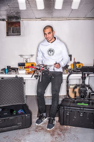
Jorge Jovel of Black Sheep Media House with a drone he built. Photo by Darren Andrew Weimert.
Perhaps the strongest sign of how far the development of drones has come was in June 2016, when the Federal Aviation Administration enacted new regulations for pilots who fly drones for commercial uses.
Among these new rules: aspiring pilots must pass an FAA exam to be certified to fly the drones, and while flying, pilots have to keep the drones within their line of sight, can’t fly them higher than 400 feet or exceed 100 mph, and are prohibited from flying over crowds not involved in the flight itself. (Pilots can apply for waivers, though, through the FAA.)
The FAA also prohibited drones from flying within a 5-mile radius of airports with control towers, such as the University Park Airport in Benner Township. The local no-fly zone covers all of Penn State’s campus, downtown State College, and nearby communities such as Houserville, Lemont, Park Forest, Unionville, and Julian. (Again, the FAA has a process for pilots to request waivers to fly in no-fly zones.)
Penn State has requested and received waivers to fly on campus for various activities, says Mike Yukish, a member of the university’s unmanned aircraft operations management team who also works as a research associate at the Applied Research Lab. He says the university has received 70 requests to fly so far since the beginning of the fall 2017 semester in late August, totaling 70 hours of flying time.
Many of the requests have been from construction companies, which send up drones to survey or inspect building work.
“They’re replacing guys dangerously climbing on a building,” he says.
The Big Ten Network used a drone at the Blue-White spring football game in April to film the tailgating atmosphere around Beaver Stadium, Yukish says.
Scientists at Penn State, like Peter LaFemina, are also finding ways to use drones for their work.
La Femina, a volcanologist and associate professor in the College of Earth and Mineral Sciences, has been flying drones inside volcanoes in Nicaragua since 2013. He and his students are creating digital models of the surfaces of the volcanoes to track changes in their shape, and he flies drones as low as 150 feet into the craters, where he records video and takes photos.
“It really allows you to get in and get a closer look than what you’d be able to get if you were on the edge of the crater,” LaFemina says.
One of the volcanoes where he does his research is Masaya, which is almost 2,100 feet high and about 12 miles outside the capital city, Managua.
Video shot in April from inside Masaya volcano’s caldera, a large depression formed after the collapse of the mouth of the volcano, shows a rocky surface and gas billowing out from the bright reddish-orange magma. The drone captured footage in 1080 pixels, the kind of high-definition picture quality available on consumer big-screen TVs.
The wispy clouds of gas are sulfur dioxide, which can be harmful to humans, and by deploying a drone, LaFemina can watch the feed on the drone’s remote control, hundreds of meters away, avoiding exposure to the gas.
“You no longer have to be right there to make the observations – you can send in the drones,” he says. “For volcanologists, that’s a big deal.”
As a photographer, Michael Houtz is used to taking his digital SLR camera wherever he goes in case he spots something that catches his eye. And over the past several years that he’s been using drones to shoot still images for clients of his photography business, the aircraft has joined the camera as another piece of equipment that’s always with him.
“I wonder what it will look like at twilight with fireworks going off or the rainbow that just happened,” Houtz says. “The idea, for me, it’s like with a camera, you always want to have it with you. The same thing with a drone — you want to be in position that you see something you want to be able to capture.”
On the business side, he said many of his clients use his aerial photos in marketing or advertising. For instance, he took aerial photos of custom-built homes for a local homebuilder and a water tower constructed by an engineering firm.
He says the photo quality has improved since the days he strapped cameras onto drones he built himself, and the drone’s remote control gives him the capabilities to adjust settings like the aperture, depth of field, and shutter speed just the same as on his still cameras.
Brad Fey took up drones as a hobby, but he’d love to make a career out of a couple of his endeavors.
A mortgage broker by day, Fey recently starting producing videos for real-estate agent friends’ high-end homes. He says he strives to get cinematic-like footage of the exteriors and has another camera for interior video.
“The bigger and grander, the better it shows on film,” he says. “Those houses need more exposure because there’s not as many buyers for those high-end homes.”
He’s also involved in using drones to create three-dimensional maps for construction companies or engineering firms. He says he can program his drone to fly a pattern at a designated elevation to capture images that software will stitch together to create a map.
Not to mention he has an Instagram and Facebook account called Dronediculous he uses to post clips, and he’s working on a music video for his band, The Feats of Strength.
“I’ve only owned my drone for eight months and I’m looking to already upgrade,” he says. “It’s going to be used in so many different ways. The list goes on and on, and if I can figure out how to be a part of that, it would be awesome to do that full time.”
In May, Gunnar Bergey hiked Tussey Mountain Trail to the mountain’s ridgetop, where he sent up a drone to record footage of the Trans-Sylvania Mountain Bike Epic, a five-day race he organizes, for future promotions of the event.
He captured birds’-eye views that show the contours of the mountain. He flew close on the bikers from behind and alongside them as they moved through the course.
He hopes the footage will add another layer of appeal to the race, and he’s posted clips of the videos on the event’s Facebook page.
“When you’re watching the screen, especially when you’re up high … it feels like you’re in a video game or you’re flying,” he says. “You can swoop around and go wherever you want. It’s really cool.”
South Hills School of Business and Technology offered its first drone pilots course this fall. It saw 20 enrollees over two sessions that taught flight safety and FAA regulations and included flying time, says Jeff Stachowski, the coordinator of the drone program.
Among the attendees was Craig Konkle from Lycoming County’s Public Safety Department. His county is looking to use start a drone program for emergency management.
For example, he says a drone can fly out over a flooded area to see just how much land is flooded and if there are people who need rescuing. A drone can survey the damage after a disaster or even whether the damage indicates a tornado struck. It can also be used for reconnaissance in hostage situations.
“There’s an endless list,” he says.
Michael Schafer, owner of Cool Pixx Media in State College, has a client who’d like drone videos and he was hoping to take the FAA test soon. And, he says the course gave him the chance to talk shop with his son, who is in the Navy’s flight school.
“Flying one of these guys,” Shafer says about the drone, “we can talk the same language.”
Melissa Steingrabe, a client care manager for local real estate agents, also took the course with the goal of taking aerial shots inside and outside of homes her agents are listing.
The instructor was Chuck Ferrell, a longtime TV news anchor who runs a video production company, Pennsylvania SkyOps, that exclusively uses drones.
“I was flying just as a hobbyist, and it blossomed into a business,” says Ferrell, who’s based in the Altoona area and works across the state.
He shot video of a farm in the Gettysburg area for an insurance company that wanted to make a map. He flew a drone to film the scaffolding on a 40-story building in Pittsburgh. He’s also shot a few news stories for WTAJ.
Stachowski says South Hills plans to offer the course again in the spring. Recognizing the various professional uses for drones, the school plans to add drone-specific components to its law enforcement and graphic arts programs.
“The transformation from drones as toys to tools is under way,” Stachowski says.
Mike Dawson is a freelance writer who lives in College Township.


