We are lucky here in the Centre Region to have so many outdoors opportunities that are just a stone’s throw away from our growing college town. Hop in a car and, in less than 15 minutes, hikers, bikers, horse riders, and runners can be at a trailhead to hit the byways of Rothrock State Forest. It is one of the reasons that people who crave outdoor adventure love to call Happy Valley home, and it is helps draw people to the area.
Over the past year, it has been great to see more and more people out exploring our trails. With the concerns caused by the pandemic, the outdoors have been a refuge for many. As we move forward, it seems as if the enthusiasm for nature isn’t waning, as trailhead parking areas remain busy with people of all ages looking to get outside.
Even before the pandemic, popular trailheads, such as Galbraith Gap (just past the Tussey Mountain ski slope) and Shingletown Gap, were sometimes getting a little too cramped for comfort. The pandemic has only added to the problem, but with a whole 96,975-acre forest to explore, there is plenty of space for everyone, and some groups are working to make Rothrock even more accessible and sustainable.
In 2018, the Department of Conservation and Natural Resources completed a Rothrock State Forest Recreational Trail Assessment with the assistance of Applied Trails Research and Kay-Linn Enterprises. After two years of looking at the current trail system and talking with various trail users, a recreation management plan for the district was completed.
The findings concluded, among other things, that the Rothrock trail system is heavily used, especially in the Galbraith Gap and Shingletown Gap areas. Also, many of the old fallline trails (trails that run straight up and down the mountain) that were developed for logging are not sustainable, especially with the high use they receive.
The plan looks to develop more sustainable trails and spread people out among the forest, using the Cooper’s Gap, Greenwood, Whipple Dam, and Musser Gap areas that don’t see as many trail users and are only slightly farther away. This would greatly enhance the recreational opportunities in this area and help to distance visitors out among the trees, so to speak.
The group Friends of Rothrock State Forest is working with DCNR to get these projects rolling by applying for grants and gaining community support. The Friends of Rothrock State Forest’s mission is to promote responsible public access of the site for current and future generations through conservation, recreation, and education.
One of the first areas in the forest to get some attention is Musser Gap. Friends of Rothrock has grant funding in the works to build 6 to 8 miles of new multi-use trails there next year.
The new machine-built trails will be forged throughout Musser Gap, over the Tussey Mountain Ridgeline, and ultimately lead to Pine Swamp Road. DCNR has helped provide some of the matching funding for the project along with other grant money, but they need more community support to keep moving toward a 10-year plan to develop and maintain 60 miles of new recreational trails in the forest. The trails are intended for all non-motorized user groups: hikers, bikers, runners, and equestrians.
Right now, work is being completed by DCNR to build a new half-mile trail, separate from the trail assessment, that will help make for a better recreational experience at Musser Gap. It serves as a good example of what people can expect from further trail development in the area.
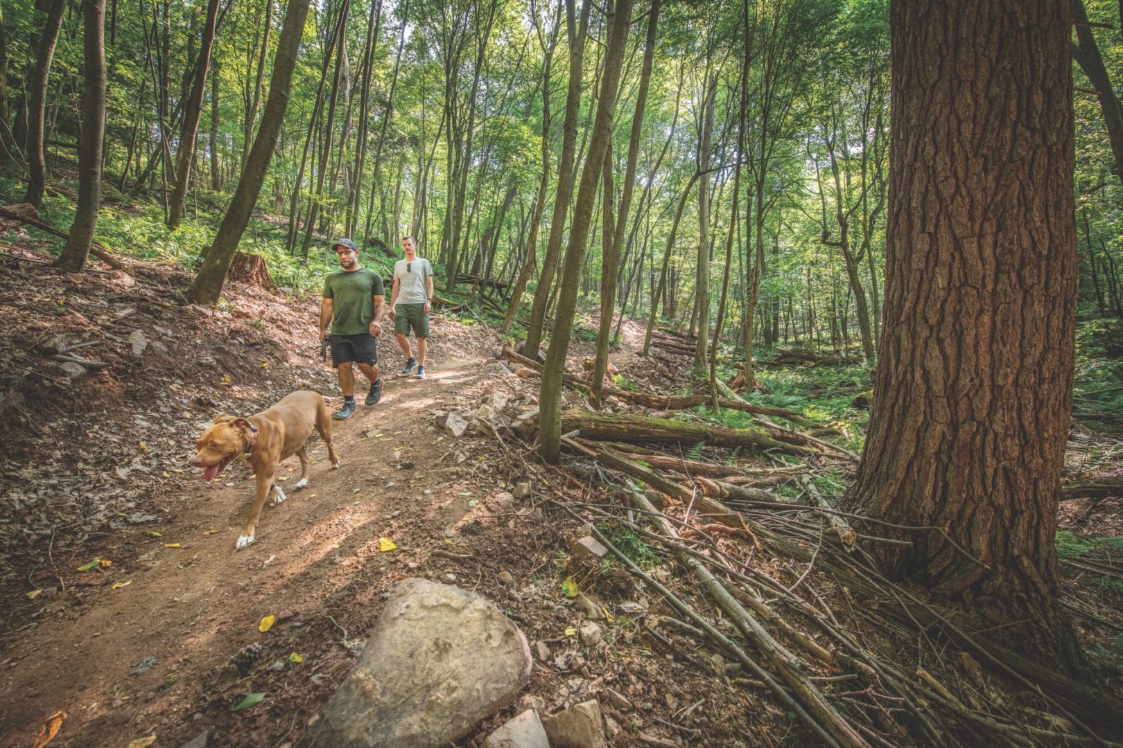
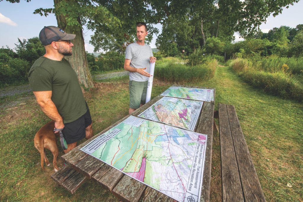
Friend of Rothrock State Forest Vice Chairman Mike Bush was nice enough to get me and my dog Peggy out to Musser Gap to show us what is going on.
We met at the Musser Gap trailhead parking area, located along Route 45. If you are coming from downtown State College, drive west on Route 26 for approximately 4 miles and then hang a left on Route 45 east. A gravel driveway a mile up the road takes you up to the large parking area.
Clearwater Conservancy bought the Musser Gap land back in the 2006 to protect it from a proposed residential housing development. According to DNCR the 423-acre mountain gap environment is an important area because it recharges groundwater and creates critical wildlife habitat. The land was transferred to DCNR Bureau of Foresty in 2007, providing another gateway to the forest. Clearwater bought an additional 281 acres on the north side of the ridge and transferred it to Rothrock State Forest.
The Musser Gap Greenway connects people from town to forest with a non-motorized, multi-use path that cuts across Penn State land between Whitehall Road in Ferguson Township and Musser Gap.
This allows access for pedestrians and cyclists to the forest from downtown by the Centre Region bikeway system and the Greenway to the trailhead. With the trail enhancement coming to Musser Gap over the next year, this area will provide a great opportunity for the whole community to experience nature.
Trail-building is no easy thing, especially in the rocks and roots of central Pennsylvania. A trail designer is working to finalize the plan for the new 6 to 8 miles of trails before construction bids are sent out next fall, but Bush said there are not many people who are expert at building trails on rocky landscapes like we have here.
“If you have been out to Rothrock, you know there are a lot of rocks out there, and that requires a group who has worked with rocks before and is willing to break some equipment along the way,” says Bush, with a laugh. He said the group hopes to have trail-builders start on the project in spring, as soon as it is dry enough.
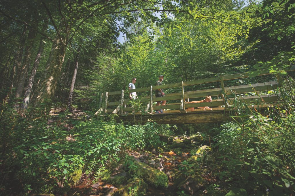
Meanwhile, the current trail system at Musser Gap provides plenty of options for exploring. Trail maps are available at the trailhead. From the trailhead the long gravel path that starts the Musser Gap Trail leads people up the forest before reaching a bridge. From there the Frog Hollow Trail breaks off to the right, which takes a sharp climb up to the top the front ridge.
Up top, a short trail to the left leads to Lion’s Valley Vista, which provides a great view of the valley below. It is definitely worth the climb up the top. The Huckleberry Loop provides a nice wander around the ridge. From there, the Mountain Mist Trail connects hikers to the Shingletown Gap area, or you can continue back on the Musser Gap Trail toward the Mid-State Trail, which continues all the way to New York to the north and Maryland to the south, with plenty of other connector trails along the way. We were not going nearly that far on our trip.
Back near the bridge where Frog Hollow Trail breaks off from the Musser Gap Trail, Mike, Peggy, and I stepped right over a yellow-phase rattlesnake, giving me a bit of start, but that is part of being on the trails in this region. There are snakes, bears, and other wildlife that you need to be mindful of. Luckily, the snake didn’t seem to notice us, but we made sure to warn other hikers we saw along the way.
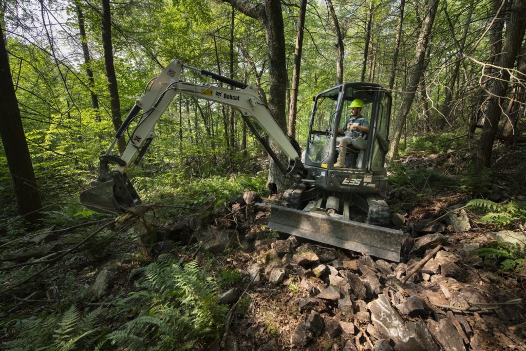
We hiked about a half mile on the Musser Gap Trail right before it intersected with a powerline. The trail was rocky and steep, with a lot of washout from the most recent heavy rain. From there we turned off the trail to head down the new, more sustainable half-mile link that DCNR trail-builder Eric Berendsen was working on. The new section should be open later this fall.
Right away, you could tell the difference between the old trail and new section Berendsen was building. It gently traveled down the landscape through a ravine-like setting, contouring with the landscape. Thick tall trees were all around us.
There were gullies built in for water run-off, and there were very few rocks to trip you up. The trail was wide enough to allow for easy passing. I could just imagine running or biking along the trail, smoothly going in and out around the rocks and trees.
Eventually we came to the area where Berendsen was working, and I could see how difficult a job it is to build a trail in this area. He was working a section that was at least 50 yards long and was completely composed of loose rocks that would not make for good trail. With machinery, he is going to top the rocks with usable soil. Volunteer groups from Friends of Rothrock have been out to help him make finishing touches on the trail, something he said he is grateful for.
That kind of support is needed all over as Friends of Rothrock continues to move forward with its mission. Trails need to be maintained and looked after. The Friends of Rothrock website has ways for interested parties to get involved and workdays scheduled in different part of the forest. The website, www.friendsofrothrock.org, also has hiking suggestions for those who are looking for a new way to explore the forest.
This story appears in the September 2021 issue of Town&Gown


