
Up in the Moshannon Forest, on the western edge of Centre County, the Allegheny Front Trail provides seemingly endless options for people looking to enjoy either a simple day hike or an overnight backpacking experience.
With varied terrain that ranges from scampering along five trout streams, to bog crossings near Black Moshannon Lake, to moderate rocky climbs, to hiking on the edge of the Allegheny Plateau with views galore, the roughly 42-mile AFT has a little something for every hiking skill level.
The trail loops around Black Moshannon State Park, cutting through the park for about 2 miles where it intersects with the popular Moss-Hanne Trail. The trail and road system of the park and state forest offer plenty of intersections along the AFT.
So, if you are looking to try your first multi-day backpacking trip, the AFT has you covered, with a 42-mile, not-too-strenuous (but, really, all miles are somewhat strenuous when you are carrying a pack) loop hike that is usually completed in two, three, or four days (most people take three days).
Or, if you are looking for a day hike that is moderately challenging, look no further than the AFT, where you can connect to other trails to make loop hikes of many different distances.
And, if you have a little spare time and want to take a relatively easy out-and-back walk in the woods, the AFT is close and accessible, just a short car ride from State College, Bellefonte, and Philipsburg.
One of those “relatively easy” out-and-back hikes leads to two of my favorite lookouts in all of Centre County – Ralph’s Majestic Vista and Ralph’s Pretty Good View – both just under a mile hike from where the trail intersects with Underwood Road.
The AFT is a relatively new trail, built in the late 1990s by the Penn State Outing Club, Ridge & Valley Outings Club, Quehanna Area Trails Club, and the Keystone Trails Association. Those two notable views are named after Ralph Seeley, a local trail legend who was instrumental in designing and building the AFT.
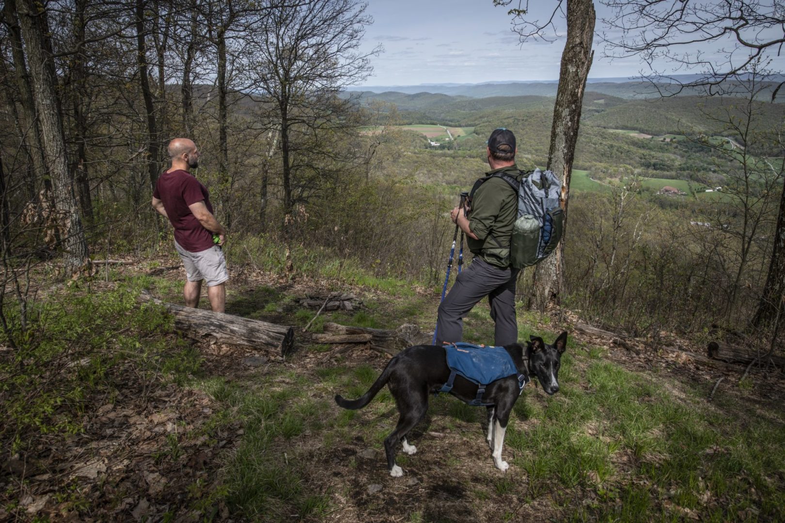
My friend Mark Badger completed the 42-mile AFT loop over a weekend earlier this spring. I asked him to join me for a quick hike up to Ralph’s views to share his experience.
We met at the trailhead on a beautiful May day, me with my trusty four-legged hiking partner, Peggy, and Mark with his super-friendly dog, Dave. Dave and Peggy are hiking buddies, and they were happy to tag along with each other. Mark was smart and packed lots of treats, and Dave was all geared up in his dog backpack (even the pups have to carry their own weight).
To get to this trailhead from Julian, follow Beaver Road west toward Black Moshannon Park and take a right on Underwood Road. There is a parking area at this junction that can make it easy to miss if you don’t realize there is a road there, too. From there, follow Underwood Road about a mile until you see a wooden AFT trail marker and a few parking spots. To get to Ralph’s views from the parking area, follow the trail across the gravel road heading east. From there, stay on the trail and follow the orange blazes.
Hikers climb a moderately steep incline of a little less than 200 feet over the first half-mile or so before they start descending toward the first of the views. Before getting there, trail-goers must step carefully over a rocky pass with pillar-like formations jutting up on each side of the passageway, making the trek a little more fun.
Hiking continues downhill for a few hundred yards when suddenly, the trail opens up and hikers are treated to the first lookout, Ralph’s Majestic Vista. Marked by a trail sign, the view sweeps across the valley below. In the distance, far over the Bald Eagle Ridge, Mount Nittany and Tussey Mountain are visible. It truly is magnificent, and well worth the trip, but I urge hikers to not stop there; continue another quarter-mile or so.
At that point, hikers will come across the biggest understatement ever, Ralph’s Pretty Good View. When we got to that point, I made my requisite joke: “That is pretty good.” The vantage point gives a different view of the valley below as it stretches northwest. Pastures and forests cover the landscape and you can see the Bald Eagle Ridge for miles. “Pretty good.” It makes me chuckle every time.
Mark and I turned at that point and retraced our steps back to the trailhead, but the trail goes on along the ridge for a few more miles, offering more views and some difficult climbs before it intersects with Highway 504 (where a more popular trailhead for the AFT is located), and then continues on a loop.
Have a plan
Mark is an experienced mountain man, having completed many backpacking and hiking trips in his life. To give me the full AFT experience, if only for a couple of miles, he brought the pack he carried during his trip around the AFT. Smartly, Mark packed his bag light, carrying around 20 pounds of gear and food during his overnight adventure. Every (and having completed many backpacking trips in my life, I can’t emphasize this enough) pound adds up when you are lugging it on your back for miles at a time. Luckily for Mark, we were going just a couple of miles today.
The third time was the charm for Mark on the AFT. His first attempt was cut short because of illness, and on his second go-round he just was not feeling it, which is completely understandable; if you have to carry a pack for 42 miles, you better be in the mood to do it. Looking back at his completion of the hike this spring, Mark says the AFT is not overly challenging.
“I just made it challenging by attempting it as an overnight trip,” says Mark. “From open woodland to rushing streams and rivers, scenic overlooks, tight pine forest and marshland, there is always something to attract your attention and keep you engaged with the hike. While there are some strenuous climbs, they tend to be short, with a good respite between efforts. The trail is in very good condition and that allows you to keep up a decent pace with little chance of an ankle injury, or worse, as long as you pay attention.”
Mark says there are many good places to pitch a tent along the trail, “many with fire rings, and some with seating … and all next to good water sources.”
Mark hasn’t run into many critters on the trail, seeing one rattlesnake on the main road; but he did have a close encounter with a bear once, so hikers need to be aware at all times.
When completing a hiking trip, planning is important. Purple Lizard Map’s Moshannon and Quehanna map provides a detailed look at the trail, and other maps are available at the Black Moshannon State Park office and state forest offices.
“There are some great resources, from maps and guides to blogs and vlogs, to look at to plan the hike,” Mark says. “Planning is really important. Maybe I over-plan, but I want to be safe. While I did the trail solo, I would recommend hiking with a friend or two just in case you get into difficulty. Cell service, while improved, is still spotty on the trail.”
Another way to explore the AFT is during the Allegheny Front Trail Race 50k and Half Marathon, which is to be held August 7. The supported trail event is open to hikers and runners. Race directors work hard to make sure the course is well-maintained, putting in a lot of hours of trail work through the year.
I hope to gear Peggy up and give the whole trail a try later this year, if my nagging knee injury will let me. In the meantime, there are plenty of other ways to explore the AFT.
Hope to see you out there. Happy trails.
Staff writer Vincent Corso, an avid hiker, is highlighting some of the area’s best trails this summer and fall.


